MOMA House
Marina City
Sheldon Museum

Mass Timber
Black River ATLAS
Taubman Bridge
From advanced site analyses to construction practices to case studies to model-making, architectural research encompasses many fields of design with the help of meaningful inquiries and bold representation techniques.
CRITPRAX MODEL
Mass Timber
Contributors: Peter Arton, Andres Carmona, Kayla Lewis, Nicholas Peruski, Jacob Smith
Lawrence Technological University
Integrated Design 5
Faculty: Rachel Kowalczyk, Scott Shall


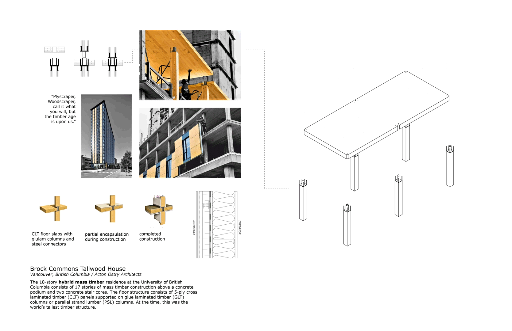
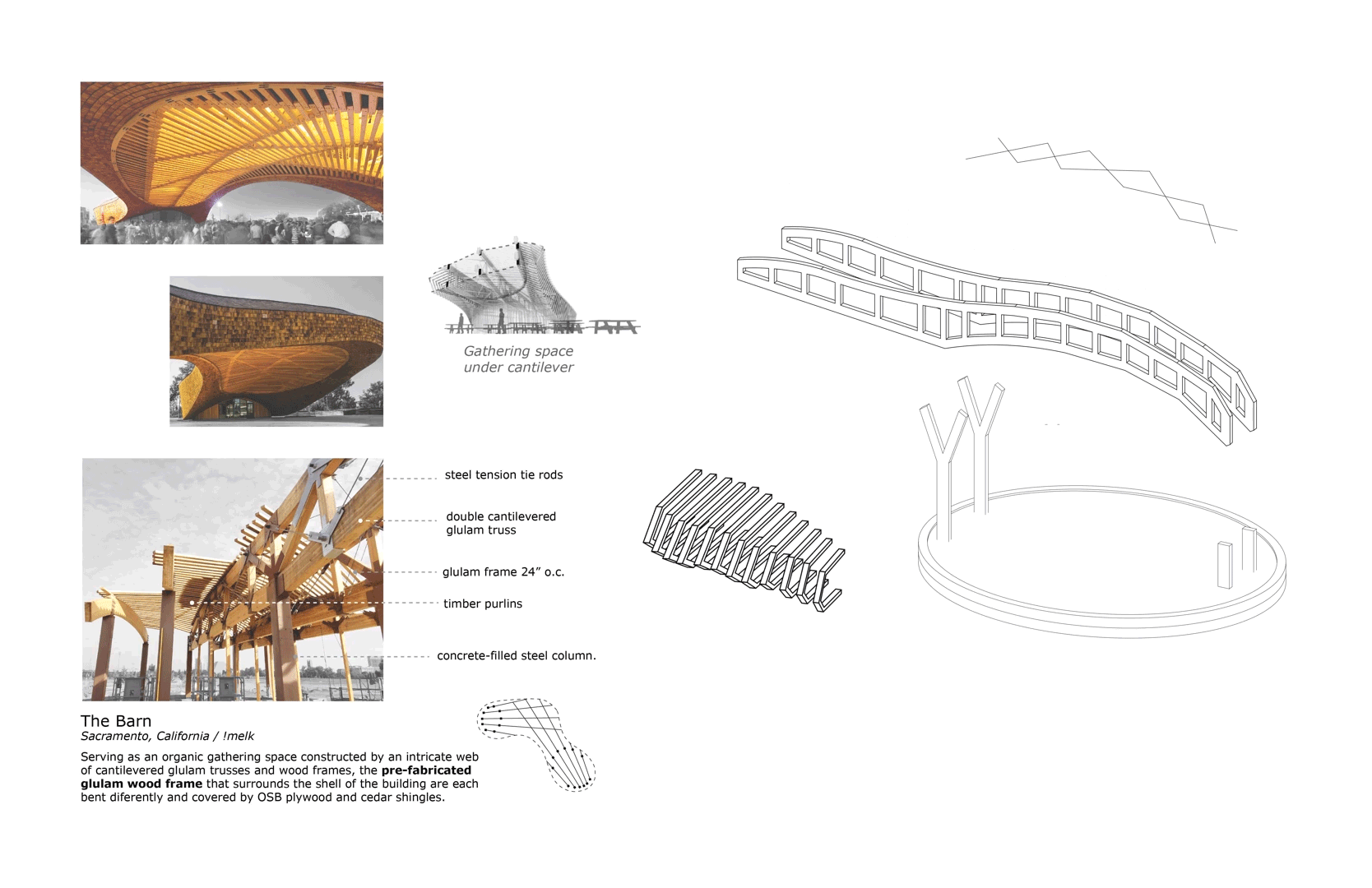
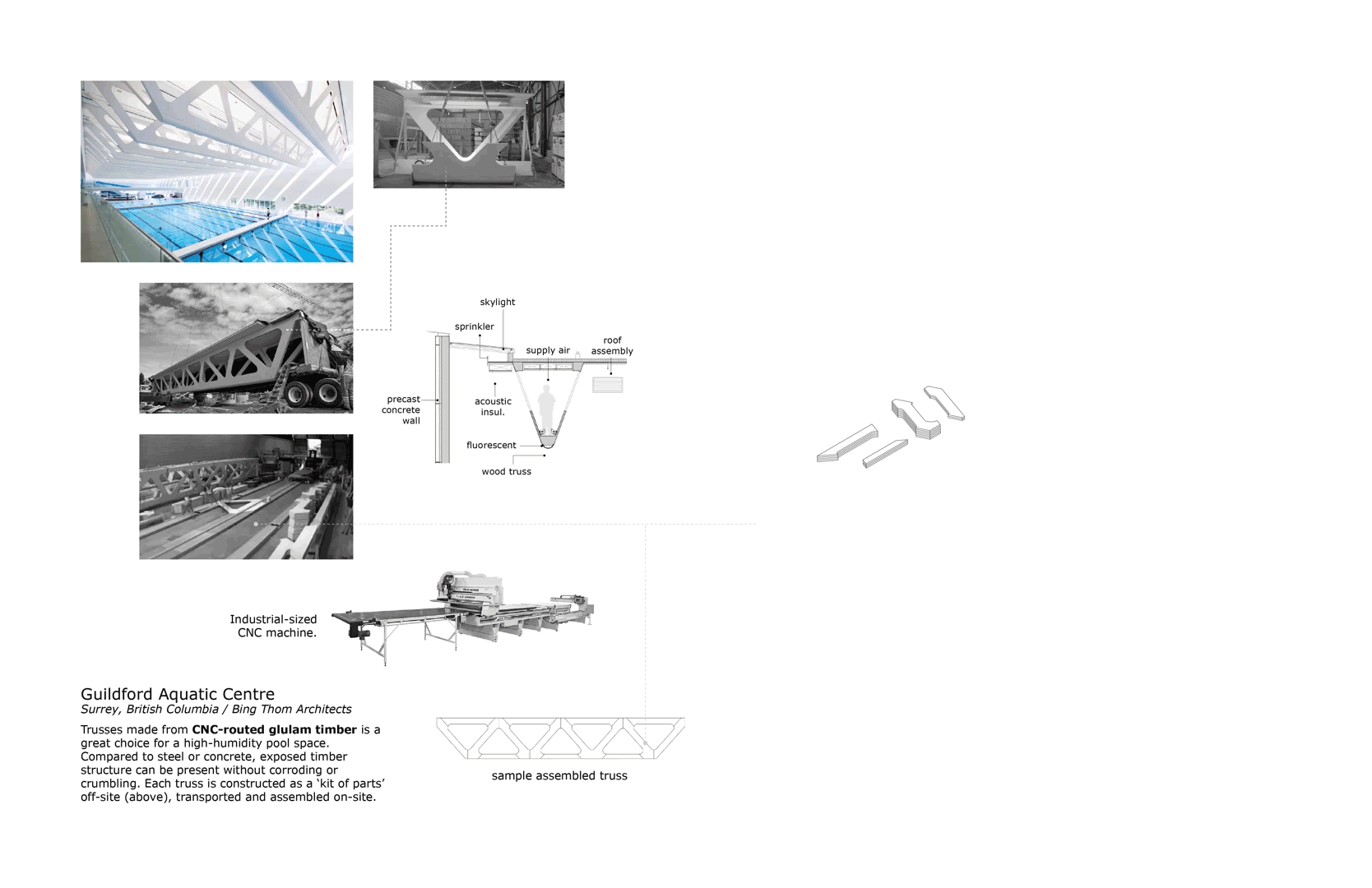
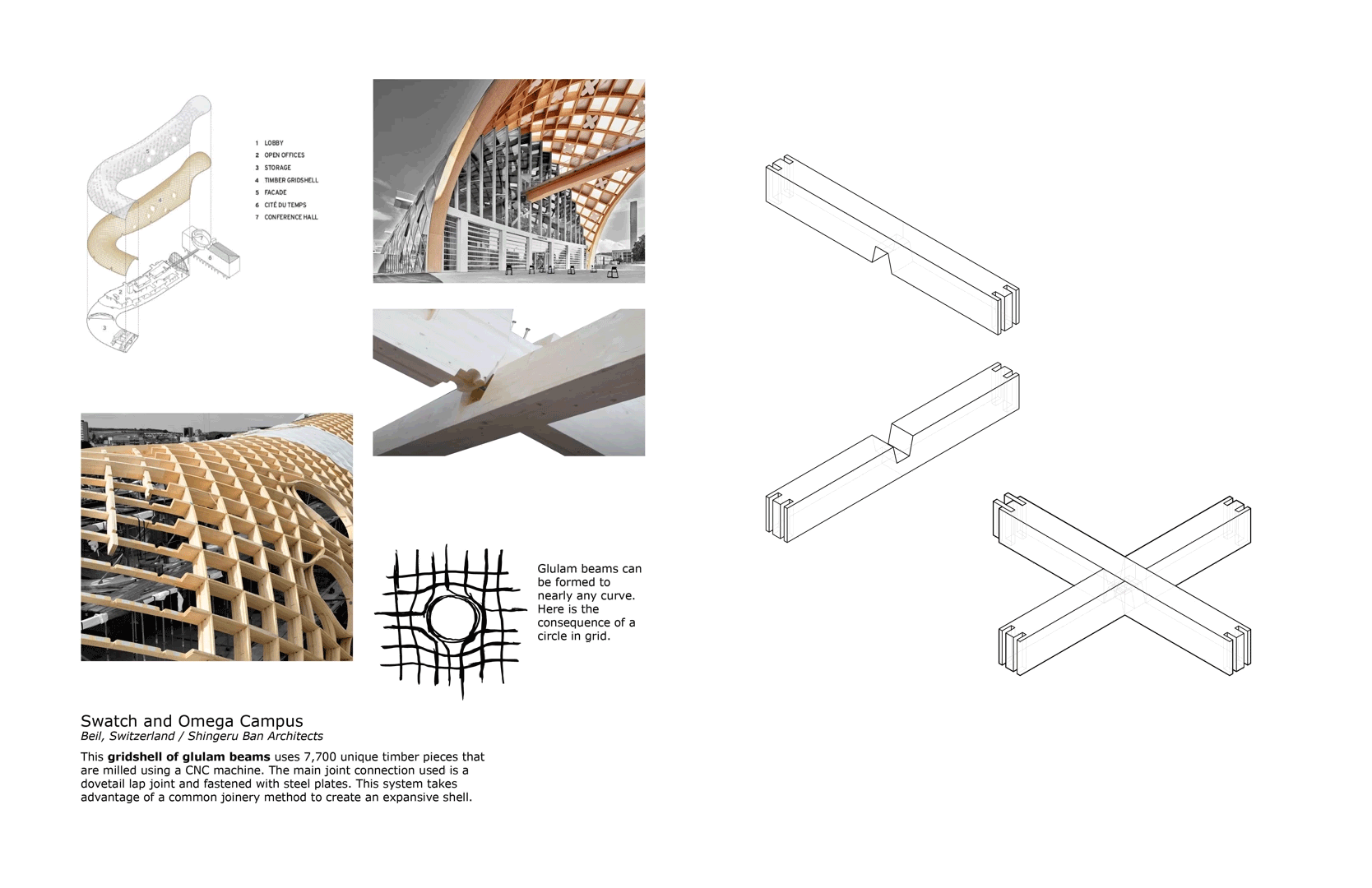
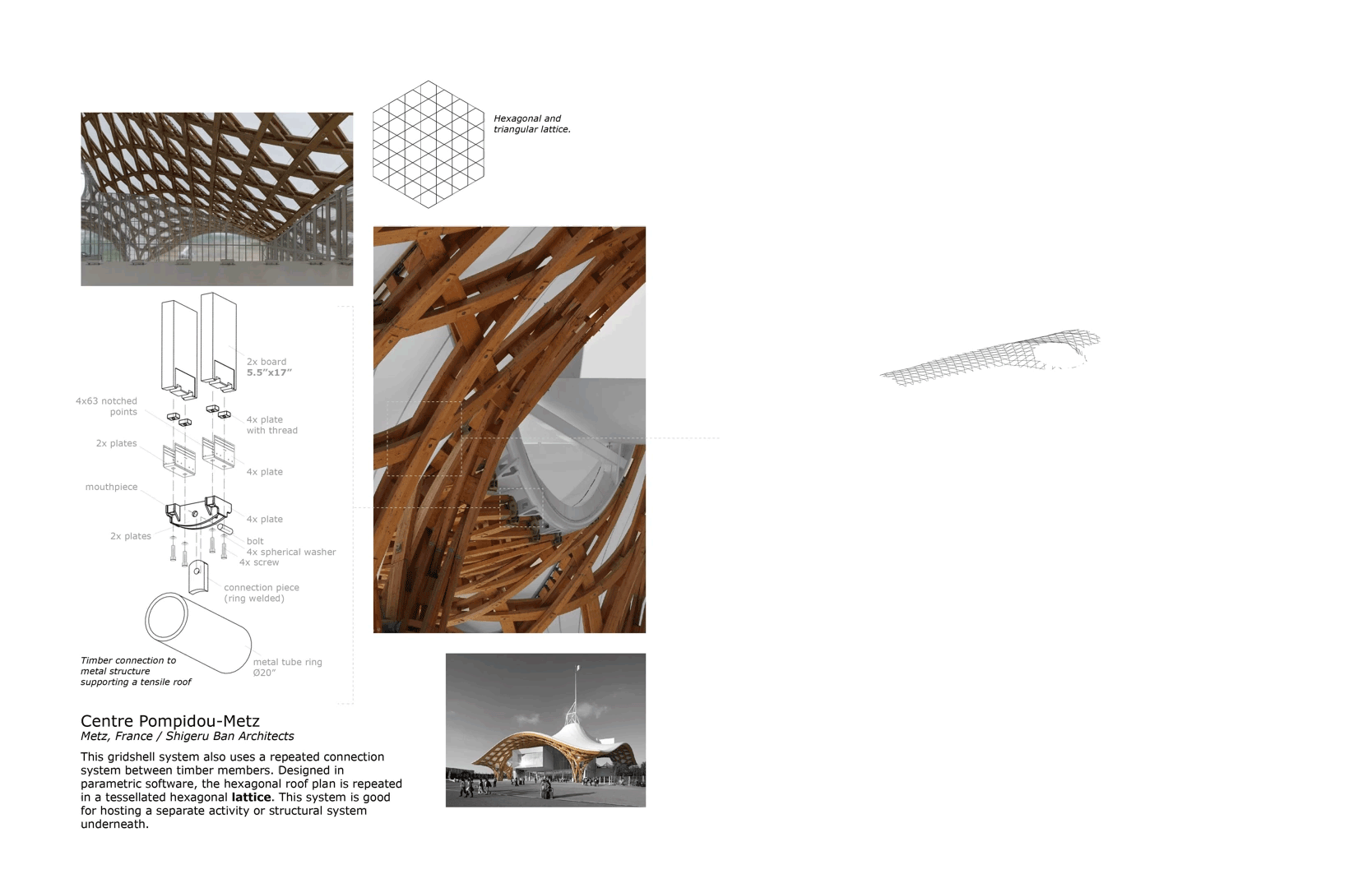
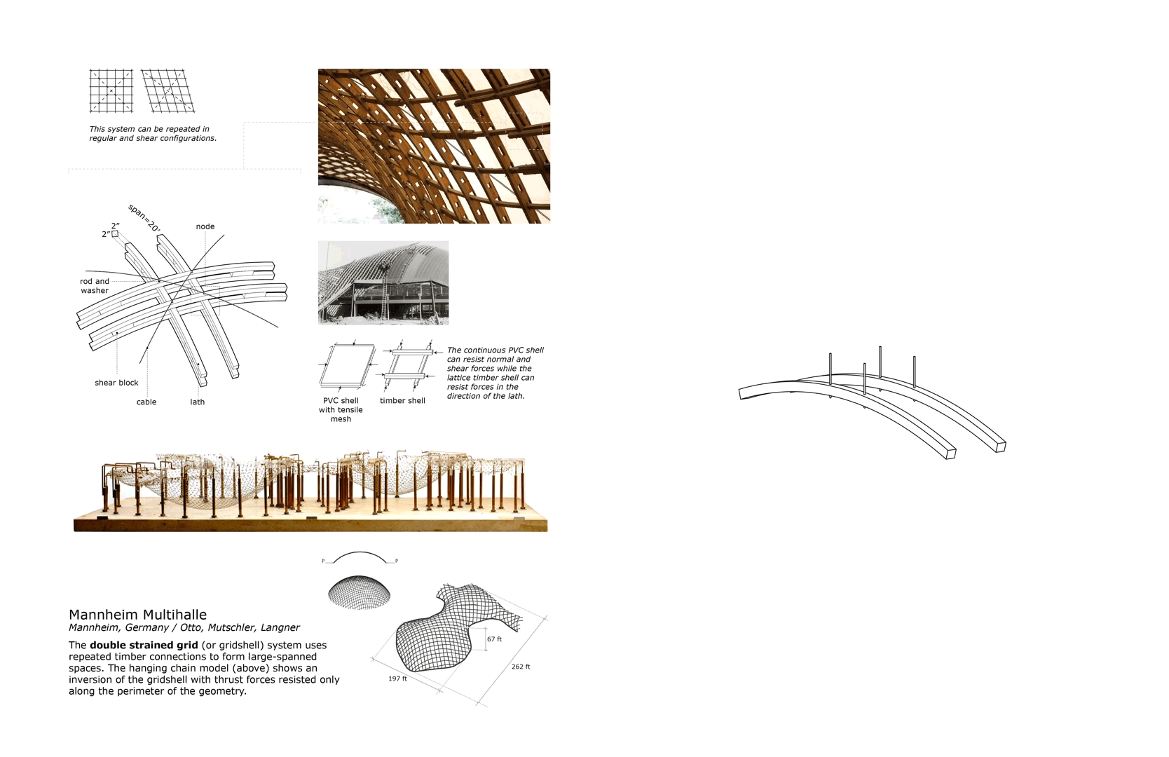
Timber is one of the earliest building materials next to stone and mud and has since transformed into a considerably innovative and newly expressive material. To discover the future of mass timber, we can look to the past as to how it has been configured and joined with other wood and non-wood members. From simple beams and columns to elastic grid shells, modern engineered timber allows for grand or subtle gestures of the beauty of the material itself. After all, it is the world’s only naturally renewable building material.
Since the 1920s, logging from forests has occurred at a stable rate to where architects can fully be conscious of the renewable resource’s life cycle. For building applications, this includes timber turning into both untreated products and treated products. The treated products for building structures is called engineered lumber which is mostly made from softwood trees. Transforming from the expression of a tree into engineered lumber, however, has the consequence of recyclability downfalls. Part of being engineered means that the adhesive chemicals (or glues) that bond layers of oriented, fibrous or particle wood causes an environmental issue. Although very good for standardized strength properties, these engineered products require specific reclamation and reusing processes to become other wood products.
Common forms of mass timber include glue-laminated timber (glulam), cross-laminated timber (CLT) and parallel-stranded lumber (PSL) among many others. Timber that is oriented where the strands run parallel to each other can create regular or curved members along an axis. Cross-laminated timber is good for structural members such as timber walls and floors that can withstand loads in a load-bearing wall manner or normal to a larger surface area respectively. As an architect or contractor, you may want to be mindful of the sizing and transporting options for timber members to be assembled on- or off-site (prefabrication).
These pages serve as a guide to the many grain and formal expressions possible with mass timber. To achieve these, timber most often has to be designed in concert with steel, concrete or other morphologies in order to perform amazing architectural and special feats. Wood as a material can undergo any design methodologies from fastener-free joinery to steel connection nodes to elastic grid shells to structural insulated panels (SIP) and virtually any shape and architectural performance you can imagine.


BLACK RIVER ATLAS (WIP)

Contributors: Anirban Adhya (Faculty Research Leader)
Nicholas Peruski (Graduate Research Assistant)
2020 Seed OUT Faculty Grant Program 2020-2021
Lawrence Technological University / College of Architecture and Design
Project Partners
Huron County Economic Development Corporation
Sanilac Regional Economic Consortium


INTRODUCTION
THE RIVER - THE CITY - THE PEOPLE
The Black River Atlas is a digital cartography project involving mapping of three specific issues in the City of Croswell, interconnected through the ecology of the Black River, a long-ignored natural element in the community: green infrastructure, public space, and environmental resilience. The atlas is a reference map for sparking conversation and framing aspirations. The City of Croswell and the Sanilac and Huron County Economic Development Council is our partner.
The City of Croswell is a small city in a rural setting in East Michigan. Croswell is situated four miles east of Lake Huron, along the Black River in southeastern Sanilac County, in Michigan’s “Thumb” region. In the face of increasing competition for economic development, environmental crisis, and political attention small towns like Croswell need attention. Croswell is a recognized yet untold American story of declining housing and infrastructure, new rural demographics, labor-market restructuring, and climate change. We want to highlight the following narratives in Croswell.
METHODOLOGY
The methodology is framed around environmental studies of several areas adjacent to the Black River located in Croswell, Michigan. Primary tool for the environmental study is conducted through environmental mapping using unmanned aerial systems (UAS).
Three inspection areas are designated along the territory or the Black River at critical intersections of the river with the city, where the river has interaction with human occupation and density (central business district), activities (landuse and events), natural topography (natural slopes, flood plain), and movement infrastructure (roads).
Black River x Downtown Croswell (river / human density / topography)
Black River x Harrington Rd bridge (river / movement infrastructure)
Black River x Sanborn Ave bridge (river / movement infrastructure /
The UAS is used for detailed inspection as well as photogrammetry to assess the condition of the project.
The photogrammetry data of each area area is used to create a digital three dimensional (3D) model for each area.
Photographs are used for a digital 3D reconstruction of the topography and structures. Different data types including a point cloud, photo mesh, and contour files compatible with Autodesk products are used for developing 2d and 3d models for urban analysis.
Using photogrammetry data collection, different data layers of open spaces, topography, surface condition, and green and blue infrastructure are mapped and then integrated into a three-dimensional model.
References
Croswell City Council (2017). City of Croswell Comprehensive Plan. Croswell, Michigan.
Haas, R.C. (2009). Black River Assessment. Lansing, MI: Fisheries Division, State of Michigan Department of Natural Resources.

Unmanned Aerial System (UAS)
double grid flight path / photo locations
geo-coordinates
3D photogammetry / point cloud orthomosaic


DISCUSSION
GREEN INFRASTRUCTURE
Over the last seven years, the city has implemented near 20 million dollars of infrastructure improvements. Careful topo-mapping is needed for a comprehensive plan to address stormwater and wastewater using green infrastructure. The Black River meanders through the city with occasional cut and widening. Where the river widens, there are large low areas. With high rainwater events and, we conducted aerial survey and drone-mapping to study open space and how water flows through the community.
PUBLIC SPACE
Croswell needs new public spaces for people’s experience and to attract new demographics. The Black River, historically hidden in the back of the commercial street, provides an opportunity to become a new front porch. The community needs good quality community access to the river. Martin Rheaume represents new demographics in Croswell and their call for wellbeing and access to nature. Working with Martin, we intend to address public space through mapping ownership and accessibility of riverfront properties in Croswell. This is critical to develop an open space oriented recreation framework for the community as well as address resilience in response to possible increase in extreme rain events on riverfront communities and shoreline settlements.
ENVIRONMENTAL RESILIENCE
Stormwater and green infrastructure is not just an environmental issue, but a social issue (public space) and an economic development issue (amenities to attract and retain new population). With climate change, large rainfall is an issue, but addressing the environmental needs could also help provide public access to waterways.
Resources:
City of Croswell Comprehensive Plan
Green Infrastructure Linking Landscapes and Communities
Urban Sustainability and River Restoration - Green and Blue Infrastructure

ECOLOGICAL TRANSECT WITH GREEN - BLUE - GREY INFRASTRUCTURE
Natural wooded areas acting as threshold between residential areas and riparian ecology - potential for recreation trails for walking/running.
N Howard Ave, the main drag for occupation and movement in Croswell.
Park constructed as green infrastructure for flood mitigation - water holding buffer zone during high stormwater events.
The waterway historically seen as a "drain" for adjacent settlements and "irrigation channel" for rural agricultural production.
Riverbank with steep slope - potential public space between the downtown and the river.
Central Business District: parking lots and paved areas - concern for fast water runoffs, waste water pipes from adjacent retail - concern for water pollution.
[This area is intentionally left blank.]
MOMA House
Contributors: Luke Blair, Nicholas Peruski
Lawrence Technological University
Visual Communication 4
Faculty: Kristen Smith, Aaron Jones
Just like a Mondrian painting or a Miesian plan, this mid-century home organizes indoor and outdoor spaces with outstretched, orthogonal lines. In plan, cells are related by surface condition or program and are defined with louvered walls and stone barriers on the building site and partitions on the interior.
In this interpretation, the red space is the definition of a stone floor sweeping from outdoor to indoor to outdoor; yellow as a notable passage; blue as play spaces with significant two-way views.

The New York Times
House in the Museum Garden
The Museum of Modern Art
11 W 53rd St, New York, NY 10019
Architect: Marcel Breuer
Exhibition: Apr 12 - Oct 30, 1949

As an exhibition for the Museum of Modern Art in New York City from April 12-October 30, 1949, the butterfly-roofed, timber-sided home presented a new vernacular to city dwellers. Now restored and located in Potanico Hills, New York, the home's soft blue interior walls, wood siding and stone floors are familiar surfaces and tones of its permanent surroundings.
The following drawings explore simple relationships and organizations of surfaces through digital drawing and physical modeling.


These drawings and models explore floor surfaces and partitions relative to the organization of the single family home.


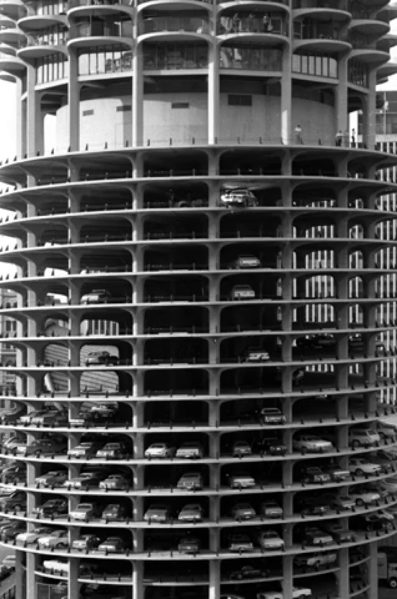
Marina City


Contributors: Brittney Meyer, Nathan Kurek, Nicholas Peruski, Maxwell Blatt,
Lewis Parenti, Nathan LeBlanc, Allexus Barnes, Jessica Brethour
Lawrence Technological University
Visual Communication 3
Faculty: Kristen Smith
This rediscovery explores the how formal elements of the Marina City towers reflect a new concept of urban life as envisioned by Bertrand Goldberg in the 1950s.
Marina City is five structures—two residential towers, a theater (House of Blues), an office building (now a hotel), and a marina. Although famously nicknamed the “corn cobs,” we found ourselves referring to the towers’ plans and divisions as “flowers, petals and the Slinky”—the residential floor plans resembling a flower with units of varying petal sizes and a Slinky-like parking ramp.
In plan, section and through makeshift virtual reality, we analyzed how the landmark’s non-rectilinear, concrete forms express a monumentality and significance of the common idea of “a city within a city.” These ideas thus call for continued research and another look at the project through the lens of social and historical significance. Check out the landmark designation.
The following traces the process of visually communicating critical habitable and circulatory areas of the towers through visual cues and a unique presentation installation.
Chicago Architecture Center


Marina City Goldberg
300-340 N. State St.;301-351 N. Dearborn St.
Chicago, Illinois
Architect: Bertrand Goldberg
Completed: 1964
The strategy for choosing any high-rise or skyscraper built in the US for an 8-student team of architecture students to study was not without great debate. We valued the revolutionary plaza of the Seagram Building, the bundled tube organization of the Willis Tower, the formal expression of Lake Point Tower and the significance of others.
We were excited for the challenges of studying the iconic parking ramp and radial floor plans, expressive balconies, its river's edge site and the opportunity to express at least two scopes of information through its two towers in a physical model.
Plus, who doesn't love a good stunt of a car driving off its parking ramp?


Team diagramming


An over-dramatized poster of what we discovered about Marina City's floor plans.
The Chicago Tribune
A stunt car drives off the parking garage at Marina City Towers during the filming of "Hunter," starring Steve McQueen on Sept. 21, 1979, in Chicago. The car crashed into the Chicago River below.

A fun-filled moment of studio-mates and professors viewing the "ViewMaster" model during final critique. (Photo: Erik Knauss)


Paper... Oops.
Chipboard... Yes!


Outlines for laser cut chipboard rings with inserts for dowel sticks and an acrylic tube.


An LED strip through an acrylic light strip makes the model express colors from balconies and marina shops that dance on the Chicago River during nighttime.
Through a string installation and interactive buttons that illuminate the model, the viewer has a sense of site scale to Lake Michigan and can interact with an unconventional annotative strategy. No more section cut line in plan—press a button, and make the section glow! (Correction: The central lift is for valet workers; not vehicles.)
Man lift for valet parking workers
Observation hub (Part 1)
Observation hub (Part 2)

Contributors (L to R) Brittney Meyer, Nathan Kurek, Nicholas Peruski,
Maxwell Blatt, Lewis Parenti, Nathan LeBlanc, Allexus Barnes, Jessica Brethour

Pin-up with string installation, relating the glowing sections to their plans.
Resources


Download Marina City Landmark Designation Report (.pdf)
Read more from ArchDaily Here.
Sheldon Museum
Contributors: Luke Blair, Nicholas Peruski
Lawrence Technological University
Visual Communication 4
Faculty: Kristen Smith, Aaron Jones
Echoing early nineteenth century museums, Philip Johnson drew from Byzantine forms of freehand arches and curves and gold leaf of the Rococo style. The Sheldon Museum of Art's Sculpture Hall is a space where the entasis of a column and the pendentives that surround elliptical ceiling panels create a visually sculptural and sweeping environment. Built from travertine and topped with a luxurious gold, the museum stands as a monument to both the art it homes and the architecture of yesterday that inspired it.
This study focuses on how the museum's seemingly simple yet complex geometry is revealed to the viewer. It traces operations of achieving a digitally fabricated representation of the museum's forms through 3D printing and an understanding of its integrated construction systems.

Sheldon Museum of Art
12th and R streets on the campus of the
University of Lincoln, NE 68508
Architect Philip Johnson
Completed: 1963


A worm's eye view is a drawing projection that is advantageous for understanding and expressing interesting ceiling and elevated interior conditions which otherwise would be hidden in an aerial or plan view.
This drawing is cut at the first floor and explodes elements along the Sculpture Hall to reveal the array of gold buttons.


en·ta·sis
/ˈen(t)əsəs/
noun
a slight convex curve in the shaft of a column, introduced to correct the visual illusion of concavity produced by a straight shaft.


A non-lossy process of 3D modeling in Rhino 6 software: This method involved duplicating an entire ceiling segment, for example, while adding sequential modeling commands to prevent loss of steps during trial-and-error.
With the goal to 3D print the elements, complex geometries can often "fail" if modeled incorrectly. In terms of additive manufacturing, it should be "water tight" so the 3D printing dialogue can recognize the geometry correctly. This theme park of many digital models in the Rhino modeling space is the result of getting it right!


Resources
Historical Registration (.pdf) with high resolution imagery.
Historical Registration (.pdf) with high resolution imagery.
Taubman Bridge

Contributors: Jessica Brethour, Nicholas Peruski
Lawrence Technological University
Visual Communication 2
Faculty: Fernando Bales
Building a balsa wood sectional model is a classic first-year architecture school exercise using field measurements, diagrams, and photography to reveal many perceptions of architectural spaces.
This bridge connects the Taubman Student Services Center and the Science Building at Lawrence Tech and acts as a study lounge that hovers over a main access point to the center of the university campus. View in Maps


Volume is a heavy consideration in operative design
where geometric toggling and designing of volume vs.
void influences spacial conditions.
Thus conditional design considers the program of the space (its purpose) and how creatures interact with volumes and voids.
Spaces that seem short, slow, tall, or fast are influenced by these design functions.
Studies of this space were sketched and diagrammed to understand their respective formal elements as they relate to the above adjectives.


Views when spaces are used as slow ones.
Circulation paths that are fast.

A threshold that is either tall or short whether you are above or below.

CRITPRAX PAVILION MODEL
Sam Luong
Richard Lupas
Rena Makki
Adriana Mantke
Anthony Marrocco
David McGrath
Maciej Michalak
Mylene Noel
Lauren Pedigo
Austin Pelfrey
Bobby Penn
Matthew Pierzchala
Priscilla Pliml
Brenna Quinn
Jason Robinson
Leah Scabilloni
Trent Schmitz
Paul Schreiber
Alec Seaman
Sophia Simone
Ellexis Szymoniak
Kayla Tear
Matthew Unternahrer
Brian Velocci
Liliana Welliver
Christopher Westerlund
Matthew Zix
Exhibition Model Contributors: Luke Blair, Nicholas Peruski
Pavilion Contributors:
Faculty
Karl Daubmann, Scott Shall, Jim Stevens, Kristen Smith
Students
Mai Abdel Khaliq
Riham Alsarout
Jo Alter
Danielle Bohannon
Christopher Boucher
Andrew Donlin
Cara Folkert
Christopher Garcia
Roberto Gonzalez
Arthur Harris
Steven Holub
Rawan Ita
Leah Klynstra
Fiorela Lesaj

Instagram @ltu_critprax
About the Critical Practice Studio
"The studio culminates in an inhabitable, exterior structure in the CoAD courtyard, which is built by participating students in one week. These ambitious circumstances of scale, logistics, and labor pressurize the studio interests and kept the focus. The studio explores design and construction while not suffering the fate of design-build studios that conclude with pointing to a thing and saying simply, “There it is.” Instead, the requirement of the built work of the studio is to be discursive, projective, and exist as a proof of concept, suggestive of other opportunities that are broader than the specific, applicable circumstances of the CritPrax Pavilion."

Building an Exhibition Model
After the completion of the Critical Practice Studio mid-summer of 2019, studio partner Luke Blair and I (who were not part of studio course) were approached by the studio's professors to build a scale model of the CritPrax project. This would be featured as an exhibition piece for the Design x Technology event in Downtown Detroit.
We combined the students' work with our own on-site measurements and observations to create a craftful 1"=1'-0" model of the pavilion.
Immense credit goes to the students and faculty who make this design-build project a joy to experience in the college courtyard. The following serves as a behind-the-scenes of our process in crafting a very, very large model as well as the success of the exhibition on Sept 26, 2019.

We analyzed the studio's BIM model of the pavilion and created our version of an accurate digital model of the surrounding courtyard site down to the very bricks.


Luke leading the wooden pavilion model (bass wood, acrylic, LEDs) and me leading the white courtyard model (mat board, PLA, acrylic).
The model rests on a cardboard and a foam insulation board base.


Replicating the courtyard's entry stairs, rails and structure.


3D printed figure standing at top of pedestrian tower within forest of bass wood sticks representing the timber 2x4's.


Featured as the Design x Technology showcase of Detroit Design 139's exhibition for the 2019 Detroit Month of Design at 1001 Woodward Ave.

©2019 - Jamie Feldman